Examining the roles of visualizations in people’s understanding of uncertain storm surge forecasts, interpretation of risk, and decision-making
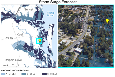
Local-scale maps illustrate uncertainty in a hypothetical storm surge forecast.
A new study published in The International Journal of Disaster Risk Reduction explores how different aspects of geospatial visualization influence individuals' understanding and relatability of storm surge information. Exploring various storm surge visualizations in focus group settings highlighted consistent themes and diverse interpretations of hurricane storm surge flooding forecasts. The study showed that using storm surge forecast maps at different scales, alongside realistic images or 3D animations of flooded areas, was effective. Maps featuring well-known landmarks and labels were useful in helping participants pinpoint their locations and evaluate storm surge threats. However, people from urban areas, barrier islands, and rural coastal areas viewed the information through the lens of their specific local and personal experiences. This research demonstrated that better understanding of how people engage with various types of geospatial representation of uncertain forecasts could inform storm surge risk communication.
Full Article: Examining the roles of visualizations in people's understanding of uncertain storm surge forecasts, interpretation of risk, and decision-making
Olga V. Wilhelmi, Rebecca E. Morss, Heather Lazrus, Jennifer Boehnert, Jill M. Gambill,
International Journal of Disaster Risk Reduction. Volume 107. 2024.