Increasing Usability of Land Cover Change Information with Geovisualizations
Copyright University Corporation for Atmospheric Research
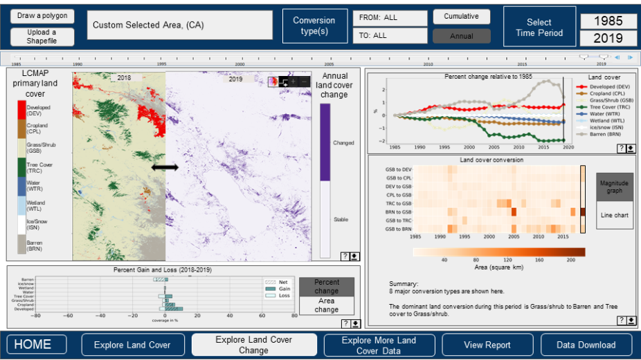
Addressing complex Earth System science and societal problems requires information about land cover and land surface change. Many important activities and decisions, ranging from monitoring post-disaster recovery to developing coastal resilience plans rely on the land cover and land cover change data. Data visualization plays a central role in the usability of land cover information in decision and policy making. With the goal to increase the usability of land cover data and to better communicate changes in land cover to a broad range of stakeholders, NCAR GIS Program partnered with the USGS EROS Center to design a land cover change data visualization and dissemination platform.
By adopting a user-centered approach, gathering feedback from potential end users, and utilizing modern data visualization and geospatial analytic concepts and methods, the project team developed a dashboard prototype. The design and functionality of the dashboard were informed by the needs of the land / resource management and planning community while embracing the complexity and spatio-temporal dimensions of the USGS land cover change science products. Intuitive design and the integration of maps, graphs and various display options enable users to interact with the data, see trends and patterns, discover spatial relationships, and gain a deeper understanding about land cover and land cover change across the U.S. The ultimate goal of this project is to provide data-driven support for land and resource management and planning decisions. The project was funded by the USGS. For more information, contact Jennifer Boehnert.